

Andheri East to Andheri West: Distance, Routes and Travel Time (2026 Guide)
Dasadia Editorial Team · Updated August 2026
The 30-Second Answer
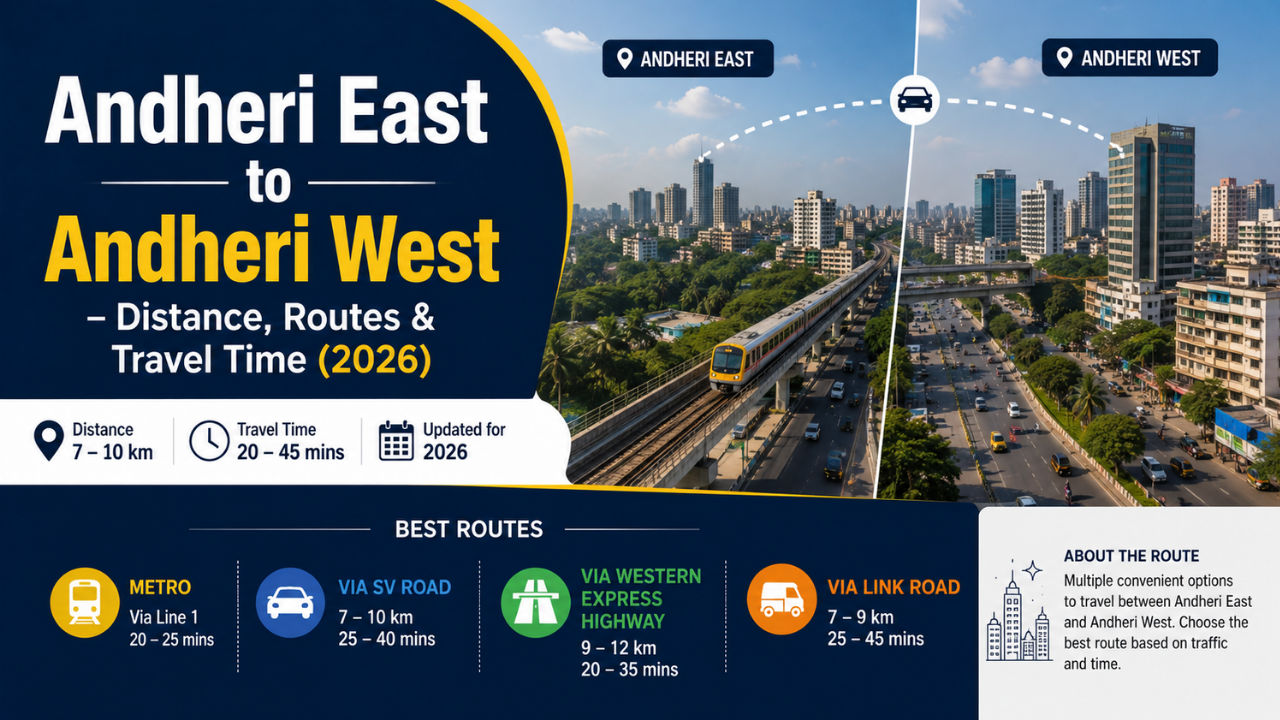
Andheri East and Andheri West are two halves of the same suburb, split by the Western Railway line and the Western Express Highway. The point-to-point gap at Andheri station is barely 1.5–2 km, but there is no straight road across — you must use a bridge, a subway or the metro. Depending on which crossing you pick, expect 2 km to 7 km of actual travel and anywhere between 7 minutes and 40 minutes. The metro is the only option whose journey time barely changes at rush hour or in the monsoon.
Source: Rome2Rio · Lokmat Times · Mumbai Metro One
Executive Summary — Key Takeaways
- Straight-line gap: the two sides meet at Andheri station and are separated by roughly 1.5–2 km of rail corridor and highway.
- Road distance between locality centres is quoted at about 6–7 km, because vehicles must detour to the nearest legal crossing.
- Gokhale Bridge — the main road link — is 511 m long, 27 m wide, spans 90 m over the tracks and has been fully operational since 11 May 2025.
- Andheri Subway is the shortest alternative but shuts in heavy rain: it was closed for about five and a half hours on 18 August 2025 with water reported up to five feet deep.
- Metro Line 1 (Versova–Andheri–Ghatkopar) crosses in roughly 7–8 minutes between Western Express Highway and D N Nagar, with trains every 3.5–5 minutes at peak.
- Walking across the Andheri station foot overbridge and skywalk takes 10–15 minutes and costs nothing.
- From 1 September 2026, the minimum auto fare rises to ₹27 for the first 1.5 km and the minimum taxi fare to ₹33.
Source: Lokmat Times · The Week · MMRDA · Free Press Journal
How Far Is Andheri East from Andheri West?
The honest answer is that there are two different distances, and confusing them is why online estimates vary so wildly. The first is the physical gap. Andheri East and Andheri West are administratively the K/East and K/West wards, home to roughly 8.5 lakh and 7.7 lakh residents respectively, and they meet at Andheri railway station. If you stand on the west-side platform and look across, the east side is a few hundred metres away. Add the width of the rail corridor, the station complex and the Western Express Highway and you get a gap of about 1.5 to 2 km between the two commercial centres.
The second distance is what your vehicle actually covers. Because you cannot drive over the tracks except at a handful of points, distance calculators routinely return 6 to 7 km for an Andheri East to Andheri West trip — that figure includes the approach roads and the detour to the nearest crossing. Public-transport planners, which measure station to station rather than centroid to centroid, report a much shorter hop of roughly 3 km. Both are correct; they are simply measuring different journeys. For planning purposes, work with the crossing you intend to use rather than a generic distance.
Every Crossing at a Glance
Times are indicative door-to-door estimates for a crossing between the station areas on either side, and vary with your exact start point.
Source: Free Press Journal · Citizen Matters · Rome2Rio
Road Routes: Bridges, Subways and Flyovers
Gokhale Bridge is the route most Andheri residents mean when they say “crossing over”. The reconstructed Gopal Krishna Gokhale bridge links the Western Express Highway on the east with Swami Vivekanand Road on the west via Teli Gully. It measures 511 metres by 27 metres, carries a three-lane motorway with walkways on either side, and runs 90 metres over the railway tracks. After a partial collapse in 2018 and a full closure from November 2022, the first arm reopened on 26 February 2024 and the entire bridge became operational on 11 May 2025. Residents’ groups estimated the second arm alone would save commuters up to 15 minutes per trip.
Andheri Subway, the underpass between Andheri and Jogeshwari stations, is the shortest alternative and carried the bulk of east-west traffic while Gokhale Bridge was shut. Its weakness is drainage. In July 2025 it was closed with roughly two feet of standing water and traffic was diverted to Gokhale Bridge and the Thackeray flyover; in August 2025 it stayed shut for about five and a half hours after the Mogra drain overflowed. If you are planning a monsoon commute, treat the subway as a fair-weather route only.
Further afield, the Mumbai Traffic Police list the Captain Vinayak Gore flyover at Vile Parle, the Balasaheb Thackeray flyover at Jogeshwari, Milan Subway and Khar Subway at Santacruz and Khar, and the Mrunaltai Gore flyover at Goregaon as the official alternatives. All of them work, but each adds several kilometres of detour, and the Gore flyover in particular is a narrow single-lane structure that slows to a crawl when the subway shuts.
Source: Lokmat Times · Free Press Journal · Mumbai Live · India TV · The Week · Free Press Journal
Crossing by Metro
Metro Line 1, the Versova–Andheri–Ghatkopar corridor, is the one crossing that ignores the traffic entirely. It is an 11.4 km elevated line with 12 stations, opened on 8 June 2014, and it runs directly over the divide. To go east to west you board at Western Express Highway or Andheri station and get off at Azad Nagar, D N Nagar or Versova. Journey planners put the Western Express Highway to D N Nagar hop at about seven to eight minutes, with services roughly every ten minutes off-peak and every 3.5 to 5 minutes at rush hour. Trains run from around 05:30 to 23:45, and single-journey fares on the line sit between ₹10 and ₹40.
Line 1 also acts as the stitching between the wider network. D N Nagar is the interchange for Line 2A towards Dahisar, Western Express Highway connects to Line 7 at Gundavali, and Marol Naka connects to the fully underground Aqua Line 3, which has been operational end to end since October 2025 and serves SEEPZ, MIDC and both airport terminals. In practice this means a resident on the east side can now reach Juhu, Versova, Dahisar, BKC or the airport without ever touching the Andheri Subway.
Source: MMRDA · Wikipedia · Mumbai Metro One · Moovit · MMRC
On Foot, by Local Train and by Bus
Plenty of Andheri commuters simply walk. Andheri railway station’s foot overbridge connects to the metro station via a dedicated skywalk, and a shorter connector was later added to cut the switching time between the two systems. Crossing on foot from the west-side exit to the east-side exit takes roughly 10 to 15 minutes at a normal pace, costs nothing, and is completely immune to both traffic and waterlogging — which is why it becomes the default during heavy rain.
BEST buses also run across, with services between Andheri Market on the west and stops near Chandan Cinema taking around nine minutes off-peak at roughly twenty-minute headways. Local trains are not useful for this particular trip: Andheri is a single station serving both sides, so the train gets you to Andheri but not across it.
What It Costs
The revised auto and taxi tariffs were cleared by the Mumbai Metropolitan Region Transport Authority in August 2026, the first revision since February 2025, and apply across the wider Mumbai Metropolitan Region. Smart cards on the metro are cheaper than tokens.
Source: Free Press Journal · Mumbai Metro One
Travel Time by Time of Day
Andheri’s east-west crossings behave very differently across the day. Between roughly 11 am and 4 pm, and after 9 pm, Gokhale Bridge or the subway will get you across in under ten minutes. During the morning peak of about 8 am to 10:30 am and the evening peak of about 5 pm to 9 pm, the same trip routinely takes three to four times as long, because every vehicle in a suburb of more than sixteen lakh people is funnelling through a handful of crossings.
The monsoon adds a second variable. When the subway floods, its entire traffic load shifts onto Gokhale Bridge and the Vile Parle flyover, and both back up quickly. On heavy-rain days the sequence to expect is: subway closes, diversions are announced, bridge queues lengthen, and the metro and the station footbridge become the only reliable options. Checking the Mumbai Traffic Police feed before you leave is worth the thirty seconds it takes.
Source: India TV · Citizen Matters
Bridge or Metro? Pros and Trade-offs
For a daily crossing the practical choice comes down to the road bridge versus Metro Line 1.
Pros
- Door-to-door — no walk at either end.
- Best option off-peak, under ten minutes.
- Works for luggage, groceries and family trips.
- Gokhale Bridge now carries traffic in both directions again.
- Direct access to the Western Express Highway and S.V. Road.
Trade-offs
- Peak-hour times can triple.
- Andheri Subway shuts in heavy rain, pushing load onto the bridge.
- Auto and taxi fares rise again from 1 September 2026.
- Narrow footpaths on the bridge make it poor for pedestrians.
- Parking on both sides is scarce and expensive.
Source: Mumbai Live · Knocksense · Free Press Journal · MMRDA
Which Route Should You Take?
- Commuting daily at peak hours: Metro Line 1. Predictable, seven to eight minutes, unaffected by rain.
- Off-peak with a vehicle: Gokhale Bridge is the fastest and most direct road crossing.
- Short hop near the station: walk across the foot overbridge and skywalk.
- Heading to Juhu or JVPD from the east: Gokhale Bridge onto the Barfiwala flyover.
- During heavy monsoon rain: avoid Andheri Subway entirely and use the metro or the bridge.
- Coming from Jogeshwari or Goregaon: use the Thackeray or Mrunaltai Gore flyover instead of doubling back to Andheri.
Source: Free Press Journal · Knocksense · MMRDA
Fact-Check Section
- Gokhale Bridge dimensions: 511 m by 27 m, three-lane motorway, 90 m over the railway tracks — BMC via Lokmat Times.
- Full reopening date: 11 May 2025, roughly seven years after the 2018 collapse — PTI via ThePrint.
- First arm reopened 26 February 2024; Barfiwala flyover north arm realigned and reopened 4 July 2024 — Free Press Journal.
- Andheri Subway closed about five and a half hours on 18 August 2025, water reported up to five feet — The Week.
- Metro Line 1: 11.4 km, 12 stations, opened 8 June 2014, cut Versova–Ghatkopar time from 71 to 21 minutes — MMRDA.
- Metro Line 1 fares range from ₹10 to ₹40; services approximately 05:30 to 23:45 — Mumbai Metro One and Moovit.
- Auto minimum fare ₹27 and taxi minimum fare ₹33 from 1 September 2026, approved by MMRTA — Free Press Journal.
Source: Lokmat Times · ThePrint / PTI · Free Press Journal · The Week · MMRDA · Free Press Journal
Frequently Asked Questions
The two sides meet at Andheri railway station and are separated by roughly 1.5 to 2 km of rail corridor and highway. Road distance calculators quote about 6 to 7 km between locality centres because vehicles must detour to the nearest crossing.
Between 7 and 40 minutes. Metro Line 1 takes about seven to eight minutes regardless of the hour; Gokhale Bridge takes five to eight minutes off-peak but fifteen to twenty-five at rush hour.
Metro Line 1 from Western Express Highway or Andheri station to Azad Nagar or D N Nagar. It is elevated, so it is unaffected by road congestion or waterlogging.
Yes. The reconstructed Gopal Krishna Gokhale bridge became fully operational on 11 May 2025 and carries traffic in both directions.
Gokhale Bridge is the primary link. The official alternatives listed by the Mumbai Traffic Police are Andheri Subway, the Captain Vinayak Gore flyover at Vile Parle, the Balasaheb Thackeray flyover at Jogeshwari, Milan and Khar subways, and the Mrunaltai Gore flyover at Goregaon.
Yes, frequently. It was shut with about two feet of water in July 2025 and for roughly five and a half hours in August 2025 with water reported up to five feet deep. Avoid it during heavy rain.
Yes. Andheri station’s foot overbridge connects to the metro station via a skywalk, and crossing on foot takes about 10 to 15 minutes. It is free and unaffected by traffic.
Western Express Highway and Andheri stations serve the east side; Azad Nagar, D N Nagar and Versova serve the west. All are on Metro Line 1.
From 1 September 2026 the minimum auto fare is ₹27 for the first 1.5 km with ₹18.22 per additional kilometre, so a typical crossing costs a modest metered amount depending on the exact route and traffic.
No. Andheri is a single suburban station serving both sides, so the local train brings you to Andheri but does not cross between east and west. Use the metro, a road crossing or the foot overbridge.
Because they measure different things. Straight-line and station-to-station tools return around 2 to 3 km, while road-routing tools add the detour to the nearest legal crossing and return 6 to 7 km.
Between roughly 11 am and 4 pm, or after 9 pm. Avoid 8 am to 10:30 am and 5 pm to 9 pm, when crossing times typically triple.
Yes. Gokhale Bridge returned to full capacity in May 2025, and the underground Aqua Line 3, operational end to end since October 2025, connects to Metro Line 1 at Marol Naka, giving the east side new links to BKC, South Mumbai and both airport terminals.
Conclusion and Next Steps
Andheri East and Andheri West are close enough to see across and far enough apart, in traffic terms, to reshape a daily routine. The gap itself is under two kilometres; everything else is a question of which crossing you use and when. Since May 2025 the road picture has improved materially with Gokhale Bridge back at full capacity, and the metro now offers a genuinely traffic-proof alternative that also plugs into the Aqua Line at Marol Naka.
If you are choosing where to live or rent in Andheri, test the crossing you will actually use, at the hour you will actually use it, in both dry and wet conditions. That single exercise tells you more than any distance figure. Verify current fares and any traffic diversions on the official portals before you commit.
Sources and References
- MahaRERA — Maharashtra Real Estate Regulatory Authority
- IGR Maharashtra — Department of Registration & Stamps
- MMRDA — Metro Line 1 project overview
- MMRC — Mumbai Metro Rail Corporation (Aqua Line 3)
- Mumbai Metro One — Line 1 fares
- ThePrint / PTI — Gokhale bridge fully operational
- Lokmat Times — Gokhale bridge dimensions and connectivity
- Free Press Journal — Gokhale bridge reopening timeline
- Free Press Journal — official alternate east-west routes
- Free Press Journal — auto and taxi fare revision, September 2026
- The Week — Andheri subway closure, August 2025
- India TV — Andheri subway waterlogging and diversions
- Mumbai Live — Gokhale bridge reopening impact
- Citizen Matters — Andheri crossings and monsoon flooding
- Wikipedia — Blue Line 1, Mumbai Metro
- Wikipedia — Andheri metro station and skywalk
- Rome2Rio — Andheri East to Andheri West travel options
- Moovit — Metro Line 1 timings and fares
Disclaimer: This article is informational only. Distances, travel times, fares and traffic arrangements are indicative and change frequently — verify the latest figures on the official portals above before making any decision.
Looking for a home on the East side of Andheri?
Explore 153 East by Dasadia Developers LLP — a freehold residential address in J.B. Nagar, Andheri East, close to Chakala and Western Express Highway metro stations, the highway and the airport. MahaRERA registration no. PR1180002502968. Get the brochure with floor plans and amenities, or book a site visit with our team.